Sunday, November 24, 2019

The Town of Pinecliffe

At the western end of the Upper Region of the Tunnel District is Tunnel 29 and Bridge 36.45. After these scenes, the canyon opens up into the town of Pinecliffe which is the location of Cliff siding. Cliff siding is at MP 37.0, 5.8 miles from Crescent siding.

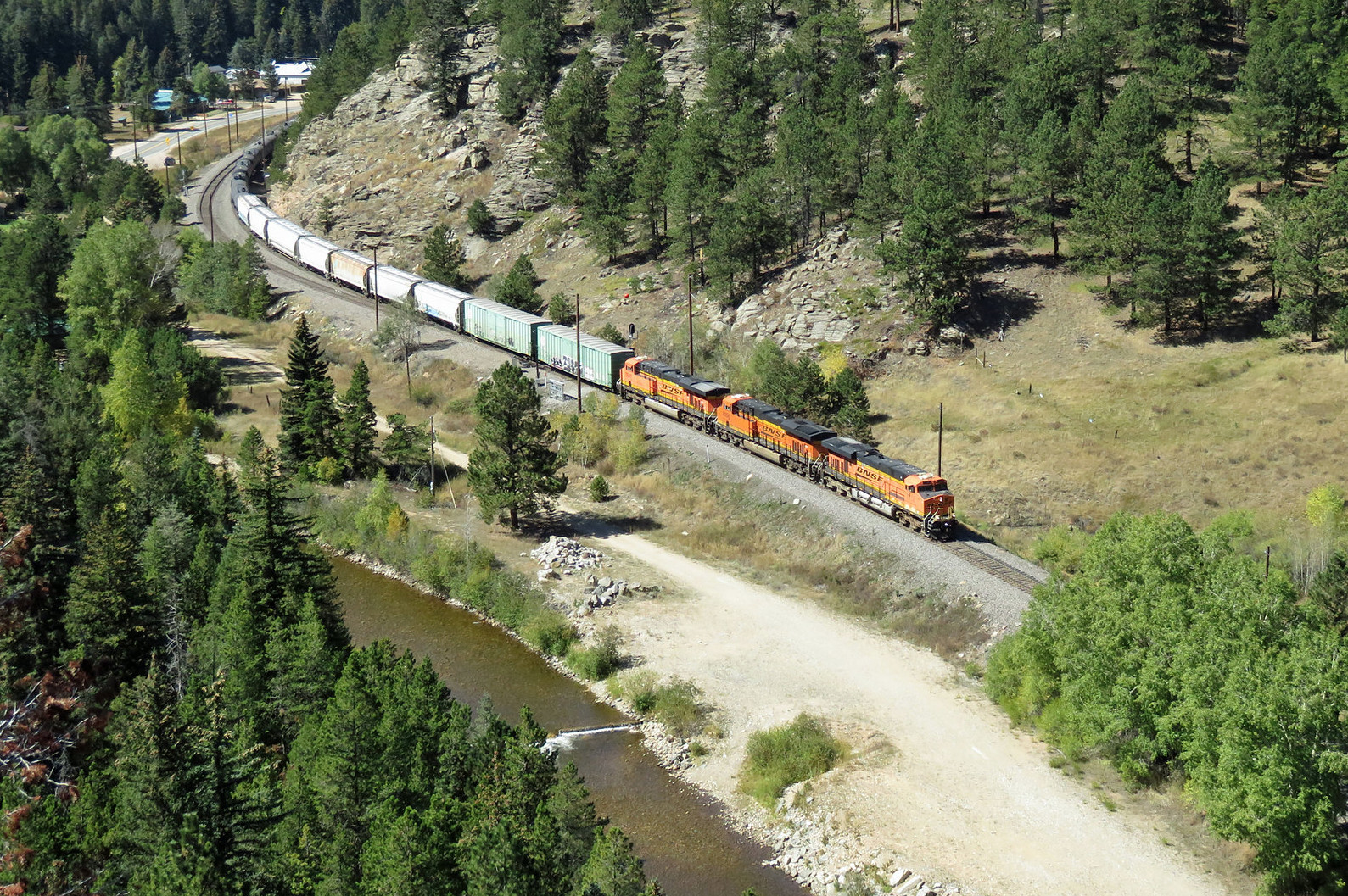
A BNSF manifest freight heads east out of Pinecliffe. Photo by David Sheppard.
Pinecliffe is a classic mountain town with a siding and a house track. I plan to add a single spur to the town, just for a little switching opportunity.

A Penny Postcard of Pinecliffe Colorado. The scene is pretty close to that of today.
Pinecliffe is a location where CO Highway 72 meets up with the mainline for the first time since Coal Creek Canyon. Although, the weather can sometimes make even that access difficult.

Pinecliffe Colorado in a "minor" snowstorm.
Physically, my model of Pinecliffe is located above the Flatiron Region of the Tunnel District and Leyden siding. So, while I have two sidings above each other, neither has a lot of switching in these locations.

Track Plan for Pinecliffe.
The plan for Pinecliffe places the town at 46.5" above the reference location. This is about 20" above the elevation of Plain siding, located nearby and below Pinecliffe. The town of Pinecliffe extends up behind the track towards the ceiling, and is planned to transition from N-scale in front of the river, to Z-scale and smaller on the other side, enhancing the sense of depth, while keeping the track easily accessible. The siding itself is a significant siding, modeled at 177" long, or almost 15 feet long, which should be long enough for any of the planned trains. Cliff siding is almost 86 feet (or 2.6 miles) from Crescent siding which is itself nearly 3 scale miles from Plain siding. This is truly a massive grade to model and climb.

6 Days, 6 Posts to Go.

Cameron Turner

Saturday, November 23, 2019

Looking for Tunnel 28 and Finding Tunnel 29

The canyon to the west of Tunnel 27 is increasingly rocky in nature. Tunnel 28 was built through a spur of rock that projected into the canyon. With a length of 124 feet, the rock through which Tunnel 28 penetrated was unstable and problematic. In 1951, Tunnel 28 was removed with explosives. So, Tunnels 9 and 28 are daylighted in my plan.

The location of the former Tunnel 28. Photo from Rio Grande Secret Places, Volume 1 by R.C. Farewell.
The mainline continues to wind its way up the canyon, rapidly closing the vertical distance between the track and the waters of South Boulder Creek. In the tight quarters of the canyon, it becomes difficult to avoid additional tunnels, and Tunnel 29 becomes necessary to continue west through the canyon. The eastern approach to Tunnel 29 leads the mainline along the banks of South Boulder Creek until another projecting ridge is encountered, requiring the shortest tunnel on the Tunnel District, Tunnel 29, with a length of 78 feet.

Eastern approach to Tunnel 29. Photo from Rio Grande Secret Places, Volume 1 by R.C. Farewell.
Exiting Tunnel 29, the main line runs along a shelf cut into the side of a shear vertical cliff face, and then across Bridge 36.45 to the other bank of South Boulder Creek.

DRGW5342, 5386, 5389, 5513, 5405 and 5410 lead a coal train west out of Tunnel 29. Photo from Rio Grande Secret Places, Volume 1 by R.C. Farewell.
In my plan, Tunnel 29 is modeled at full scale (6 inches). All the other tunnels are scaled from this tunnel in a proportion to how much longer they are than this tunnel. I did pay particular attention to the length of the shelf to the west of Tunnel 29, so as to replicate the scene above, where we have more than 3 SD40T-2 engines between the tunnel portal and the bridge. In my plan, I have 18 inches between the western portal of Tunnel 29 to the eastern abutment of Bridge 36.45.

Eastbound train on Bridge 36.45 crossing South Boulder Creek. Photo from Rio Grande Secret Places, Volume 1 by R.C. Farewell.
Bridge 36.45 is one of the signature scenes on the tunnel district. The bridge is composed of 3 plate girder bridges for a total length of 139 feet. In my plan, it had to have a prominent location.

Track Plan for Tunnel 29 and Bridge 36.45 area.
The track plan for this area extends down the right peninsula in the room, above the location of Plain siding. As mentioned, Bridge 36.45 is full size, the distance between the east end of the bridge and western portal of Tunnel 29 is similar to the real distance as well as a full scale model of Tunnel 29. The site for Tunnel 28 is an outside curve rather than an inside curve, but I think it is workable plan that captures a lot of significant scenes.

7 Days, 7 Posts to Go.

Cameron Turner

Friday, November 22, 2019

Tunnels 24, 25, 26 and 27

Beyond Tunnel 23, the main line continues to climb. With each successive tunnel, the track gets closer to the banks of South Boulder Creek, which finally arrives trackside just after the west portal of Tunnel 26.

Tunnel 24 is a bit more separated from Tunnel 23 than was the norm to the east of Tunnel 23. The approach to the east portal of Tunnel 24 is a fill over a deep chasm which was likely spanned by a trestle at some point. Tunnel 24 penetrates a rocky ridge with a bore 815 feet long. To the west of Tunnel 24, two rock cuts are used to penetrate smaller rock ridges.

DRGW5385 leads four sister units eastbound out of Tunnel 24 with a coal train off the Craig Branch. Cut into the train are two more units 70 cars back serving as a swing helper. Photo from Rio Grande Secret Places, Volume 1 by R.C. Farewell.
Tunnel 25 cuts through another rocky ridge with a 643 foot bore. The proximity of South Boulder Creek is increasingly evident in the location and curvature of the tracks and the increasingly rough terrain that it replacing the weathered and rounded features present around Crescent.

Amtrak341 leads the westbound California Zephyr out of Tunnel 25. Photo from Rio Grande Secret Places, Volume 1 by R.C. Farewell.
The 295 foot length of Tunnel 26 penetrates another rocky spur extending into the canyon. To the west, is an active landslide zone, and some evidence of previous derailments, such as one that occurred in September 1991.

The rough terrain to the west of Tunnel 27 shows the dramatic changes to the landscape as the banks of South Boulder Creek approaches track in the narrowing canyon. Photo from Rio Grande Secret Places, Volume 1 by R.C. Farewell.
As we approach Tunnel 27, having finally reached the inner gorge of South Boulder Creek, the creek quickly turns away from the track into a tight horseshoe bend that the railroad could not hope to follow. So, Tunnel 27 was used to bore through the ridge of the horseshoe. The resulting tunnel is 646 feet long. To the west, the mainline emerges on a shelf blasted into the canyon wall, that includes retaining walls that use lengths of rail in their construction.

DRGW3129, DRGW3040, DRGW5334 and DRGW5337 heads west out of Tunnel 27 through the inner gorge of South Boulder Creek Canyon. Photo from Rio Grande Secret Places, Volume 1 by R.C. Farewell.

SP357 westbound out of Tunnel 27 from the banks of South Boulder Creek. Photo from Rio Grande Secret Places, Volume 1 by R.C. Farewell.
These are dramatic and compelling scenes to model. When the elevation of these scenes, (approximately 6 feet) is considered, the view of the trains will be similar to the image above for most people.

Track plan for Tunnels 24 through 27 in South Boulder Creek Canyon.
The plan for the representation of these tunnels uses the upper wall of the garage located above the locations of Rocky siding and LDEs such as Blue Mountain Crossing and Coal Creek Canyon. The tunnels are again in proportion, with Tunnel 24 at 45.1", Tunnel 25 at 37.4", Tunnel 26 at 19.9" and Tunnel 27 at 37.7" in length. One minor modification I may make is to bring South Boulder Creek into view between Tunnel 26 and Tunnel 27. I have looked at the satellite photos of the area, and the distance to the riverbank from the track would place the river in the aisle, but I may include the edges of South Boulder Creek anyways. During this run, the grade resumes, and the mainline will climb from 40.5" to 43.875" when exiting the west portal of Tunnel 27, forming a grade of 0.83%. This is less than the actual grade, but sufficient to gain about 18" of railhead to railhead elevation over Plain siding. So, at this point, while I would like to maintain a climbing grade, I no longer need to have as much of a grade as was necessary on the second deck. Furthermore, too much grade would result in the mainline reaching the ceiling of the the garage. One additional advantage of this height though is that the mountainsides will rise well above eye level, which should make forced perspectives to increase the apparent height of the mountainsides even more effective and realistic.

8 Days, 8 Posts to Go.

Cameron Turner

Thursday, November 21, 2019

Tunnel 23 – Starting the Third Deck

Tunnel 23 is where I am transitioning to the third deck of the layout. This transition occurs near the electrical panels to the house, so I need to take into consideration how to maintain access to this area. Part of my plan to do this is to minimize the width of the benchwork, ideally keeping it to 6 inches wide or less.

East Portal of Tunnel 23 headed for Denver. Photo from Rio Grande Secret Places, Volume 1 by R.C. Farewell.
In the prototype, Tunnel 23 leaves Advent Gulch and tunnels through a substantial ridge for 1622 feet. This makes Tunnel 23 the third longest in the Tunnel District. I plan to take advantage of this length to to make this narrow scenery section just scenery, with the track hidden in a tunnel for the entire length. The ridge through which Tunnel 23 passes is quite the obstacle. Over its crest can be found Miramonte Road and a couple of mountain residences.

Track Plan for the Tunnel 23 region.
In the plan for Tunnel 23, I have provided for an 80" model of the tunnel. The benchwork starts out at 6 inches wide, and grows to 12 inches wide by the end of the module. I plan to make this stretch of track removable, although I am not sure it is going to be removable, or will be hinged to fall out of the way. The lower module in particular could be the only module I need to remove to allow access to the fuse boxes. Tunnel 23 is designed to be a flat stretch of track, owing to the complexities of this stretch of the layout. With such a long span, at an elevation of 40.5" above the reference elevation, likely to be close to 6 feet from the floor, I am expecting to support the benchwork not from the floor, but hanging from the ceiling. With careful construction, I believe that this region will work surprisingly well.

9 Days, 9 Posts to Go.

Cameron Turner

Wednesday, November 20, 2019

Wordless Wednesday

A BNSF Passenger Special heads eastbound, passing between Tunnels 2 and 3. Photo by John Shine.

10 Days, 10 Posts to Go.

Cameron Turner

Tuesday, November 19, 2019

Tunnels 19, 20, 21, and 22

To the west of Crescent, the mainline enters the Upper Region of the Tunnel District. This region transitions from the mainline residing well above South Boulder Creek to the shores of the creek. As the main resumes its climb west of Crescent, it climbs into Sawmill Gulch which narrows, until the line is forced to tunnel through another ridge line with Tunnel 19.

SP212 and SP139 lead a coal train east bound out of Tunnel 19 headed for Crescent. Photo from Rio Grande Secret Places, Volume 1 by R.C. Farewell.
Tunnel 19 is 1055' long, and is quickly followed by Tunnel 20 at 460' long. In between, lies a fill across Chamberlain Gulch, once again separating two ridges.

DRGW3064 and DRGW3136 lead an eastbound piggyback train towards Denver. Photo from Rio Grande Secret Places, Volume 1 by R.C. Farewell.
The pattern continues. Upon exiting Tunnel 20, the main crosses Advent Gulch on another fill and enters into the 667' long Tunnel 21, which allows the line to continue along Advent Gulch. Tunnel 22 is used to penetrate through a 177' spur of rocky entering into Advent Gulch, before yet another fill leads to Tunnel 23 and finally a departure from Advent Gulch.

Amtrak F40s (392, 334, 370, and 332) emerge from Tunnel 21 into one of the drainages that form Advent Gulch. Photo from Rio Grande Secret Places, Volume 1 by R.C. Farewell.

DRGW3120 leads a loaded coal train east out of Tunnel 22. Photo from Rio Grande Secret Places, Volume 1 by R.C. Farewell.

So, the initial stretch of tunnels west of Crescent brings the main line through a ridge, across a drainage and into another tunnel, repeating the process several times. The track plan does the same, climbing all the way from an elevation of 38" above the reference elevation to 40.5" above the reference elevation at the portal to Tunnel 23.

Track Plan for Tunnels 19-22.

These tunnels bring the main line back across the width of the garage to the left side of the room, headed back towards the Big 10 Curves. Again, I maintain the proportionality of the tunnel lengths (Tunnel 19 at 55.4", Tunnel 20 at 29", Tunnel 21 at 38.6" and Tunnel 22 at 13.2") as well as their spacing. Furthermore, the tunnels lie across a generous aisle of 38" wide from the rest of the layout. By the time we reach Tunnel 23, the layout has wrapped around to the electrical panels along the left wall in the garage. Dealing with these panels is the next challenge in the design, and marks our entry into the third deck of the layout.

Track Plan for Deck 2 showing how all of these elements fit into the room.
 To wrap up the tour of this deck, I've included a plan that together with the snapshots from the individual plans, shows this entire deck from the west end of Rocky Siding, to the east portal of Tunnel 23.

11 Days, 11 Posts to Go.

Cameron Turner

Monday, November 18, 2019

Crescent Siding

After a long climb of nearly 3 scale miles, we have reached the siding of Crescent, Colorado. Having visited Crescent, it truly has the feeling of being in the mountains. However, it is accessible via car, so it becomes a favorite railfanning location.

DRGW5319 and DRGW5376 lead a freight west through a meet a Crescent Siding in  May1977. Photo by Tim.
At Crescent, the rolling terrain that began to emerge after Tunnel 17 opens into a wide valley in South Boulder Canyon. In fact, below Crescent lies Gross Point Reservoir. Crescent Siding is only 5550 feet long, and is the shortest siding in the Tunnel District. However, it is halfway between Plain and Cliff sidings and provides an important point for shorter trains to pass and for crew access or helper engines to make it back down the mountain without interfering with traffic.

DRGW 5389 approaching the east end of Crescent Siding, May 5, 1988. Photo by Tom Byrnas.
DRGW3106 approaching the east end of Crescent, October 4, 1984. Photo by John Rus.
DRGW5344 leads a train downgrade through Crescent siding on October 3, 1982 on the way to Denver. Photo by Timothy Tonge.
Crescent siding rests on a sweeping curve on the western end. While short, its location makes it a commonly used siding for meets, particularly with shorter manifest freights or passenger trains.

Track Plan for Crescent, Colorado.
The plan for Crescent Siding is to allow the layout to cross the doorway on a nod under, and connect to a shelf along a half wall across the garage to a narrow shelf on the far wall that will lead the main line back over towards the Big 10 curve region, but at a higher elevation. Crescent is planned as a flat siding at an elevation of 38" above the reference elevation at Prospect Junction. While Crescent has a sweeping curve on the west end in the prototype, I have had to make the curve on the east end in the plan, so as to follow the flow of the benchwork. Like the prototype, this is the shortest siding along the Tunnel District at about 98", making it about 2" shorter than Clay siding.

I suppose it may be possible to swing the siding a little further around on the east end, and introduce at least a bit of curvature on the west end. I may need to consider that line change at some point and see if it is feasible. However, I can live with this configuration as is. Crescent serves its purpose to provide a dramatic pause in the climb, a place for trains to meet, and a point to transition from the Middle Region of the Tunnel District, to the Upper Region of the Tunnel District.

12 Days, 12 Posts to Go.

Cameron Turner

Sunday, November 17, 2019

Tunnels 17 and 18

The last two tunnels of the Middle Region of the Tunnel District are Tunnels 17 and 18. Tunnel 17 is the longest tunnel on the district, save the Moffat Tunnel at the summit. At 1730 feet in length, Tunnel 17 bores through a major ridge descending from Scar Top Mountain. To the West of this ridge lies Johnson Gulch, which drains a number of natural springs in the area. Due to the springs, water is often heard at the west portal of Tunnel 17.

Approach to Tunnel 17. Photo from Rio Grande Secret Places, Volume 1 by R.C. Farewell.
East Portal of Tunnel 17. Photo from Rio Grande Secret Places, Volume 1 by R.C. Farewell.

To the east of Tunnel 17 was a spur named Quartz. The spur was removed by 1949, but up to that point, it was a source for some mineral shipments from the area. Should I decide to employ a little modelers license, I could include this spur at this location. At a minimum, I will need to allow for space for an abandoned spur in the area.

Tunnel 18 by contrast is a short tunnel with a length of 238 feet. It penetrates a shallow ridge coming off the northern side of Scar Top Mountain, and very easily could have been daylighted, but never has been. Tunnel 18 represents the western end of the Middle Region of the Tunnel District.

SP124 heads west out of Tunnel 18. Photo from Rio Grande Secret Places, Volume 1 by R.C. Farewell.
The space for the modeled representation of this area is physically located above the Cargill area just past North Yard. That part of the layout is at an elevation of 2.5" above the reference elevation while the mainline at west end of Tunnel 18 reaches 38" above the reference elevation. The elevation climb is an amazing accomplishment.

Track Plan for Tunnels 17-18 in relation to Tunnels 7, 8 and 10.
Tunnel 17 helps achieve its length (83.2") by using the same trick of penetrating the the backdrop (previously used in Tunnels 8 and 10). However, in this case, the track of Tunnel 17 will be hidden in the mountainside above the track between Tunnels 8 and 10. At that point the elevation difference is about 5.5", so it should be easy to hide into the hillside. Tunnel 17 as modeled is a little shorter than Tunnel 10, but I may be able to address that discrepancy by moving the east portal of Tunnel 10 a few inches.

Beyond Tunnel 17, the hillsides become a bit more open and rolling as we approach Crescent Siding. Tunnel 18 is represented with a 16.5" long tunnel through the rolling ridge. Before leaving the garage, the main swings around to cross the doorway. With a mainline elevation of 38", I expect to be able to achieve a nod under crossing of the doorway with a lower edge of the benchwork at about 36" above the reference height. Since the reference elevation is likely to be around 30"-32", this places the nod under at about 66"-68", which should be fairly comfortable for many users.

13 Days, 13 Posts to Go.

Cameron Turner

Saturday, November 16, 2019

Into the South Draw and Tunnel 16


Tunnel 15 leads the main line into the South Draw, a valley between Eldorado Mountain, Crescent Mountain and Scar Top Mountain. In the South Draw, the main line makes a 180 degree horseshoe curve as part of the climb, including a penetration through Tunnel 16.

Satellite View of the South Draw Area.
Tunnel 16 is 698 feel long, and serves as a portion of the 180 degree curve. Upon exiting Tunnel 16, the main continues out of the South Draw, through the site of Old Tunnel 17. Old Tunnel 17 never was a tunnel. It started as a tunnel, but the rock proved to be too unstable and the tunnel collapsed during construction. The attempted tunnel was eventually removed, and the remains became a wide spot in the roadbed and a cut into the hillside of Scar Top Mountain. From there, the line continues around the ridge and back into South Boulder Canyon.

Looking across the South Draw towards the site of Old Tunnel 17. Photo from Rio Grande Secret Places, Volume 1 by R.C. Farewell.

Approach to the East Portal of Tunnel 16. Photo from Rio Grande Secret Places, Volume 1 by R.C. Farewell.

Track Plan for the South Draw and Tunnel 16.

The layout plan for the South Draw and Tunnel 16 is a compromise of the prototype region versus the benchwork. While I was able to include part of the 180 degree curve, I had to reverse the curve in Tunnel 16. The result is less of a 180 degree horseshoe curve, and more of a dip into the South Draw gap and then an extended run up the draw. Tunnel 16 is represented with a 39.9" tunnel, and Old Tunnel 17 is also represented. Interestingly, its location falls near the track to Tunnel 10. At this point, the main line is about 35-3/8" (above the zero elevation) at Old Tunnel 17 and at 32" within Tunnel 10. Like the prototype, the main curves sharply around the end of the ridge coming off Scar Top Mountain and heads towards Tunnel 17.

14 Days, 14 Posts to Go.

Cameron Turner

Friday, November 15, 2019

Tunnels 11, 12, 13, 14 and 15

Beyond Tunnel 10, the Moffat continues its climb up South Boulder Creek Canyon by cutting through numerous ridge lines that run down into the canyon. The first of these tunnels is Tunnel 11, a 230 foot tunnel piecing a rocky ridge on the northwestern side of Eldorado Mountain.

DRGW5389 heads east out of Tunnel 11 in 1992. Photo from Rio Grande Secret Places, Volume 1 by R.C. Farewell.
Amtrak Number 5, the Westbound California Zephyr exits the other side of the ridge through Tunnel 11 in 1995. Photo from Rio Grande Secret Places, Volume 1 by R.C. Farewell.

After a few hundred feet, the mainline encounters another ridge of Eldorado Mountain, and penetrates it with the curving 429 foot Tunnel 12. While the eastern slope is very steep and rocky  like Tunnel 11, the western side of the ridge is much more rounded.

Just West of Tunnel 12, and Eastbound coal train is about to enter Tunnel 12. Photo from Rio Grande Secret Places, Volume 1 by R.C. Farewell.
Tunnel 13 penetrates yet another ridge off the western side of Eldorado Mounatin. Tunnel 13 lies to the west of a long curved fill and to the east is another curved fill leading to Tunnel 14. The combination of curves and grade pose a significant test to trains climbing through the Tunnel District. Crews report that trains that successfully make it through to Tunnel 14 are usually successful for the rest of the climb.

DRGW5369 heads west out of Tunnel 14's western portal. Photo from Rio Grande Secret Places, Volume 1 by R.C. Farewell.
Tunnel 14, like Tunnel 13 has two faces. The eastern face is steep, and rocky, while the western side is rounded, covered with grass and trees. Tunnel 15 penetrates the last ridge running from Eldorado Mountain, and brings the main line into the South Draw. The bore of Tunnel 15 is 427 feet long. To the west of Tunnel 15, there was a deep drop into the depths of the South Draw drainage. This trestle location was filled in using materials from Tunnel 9, and the original Tunnel 17, leaving a long fill.

Western portal of Tunnel 15 with DRGW3015 emerging with a westbound into the South Draw.
The plan for this stretch of tunnels wraps around the first peninsula of the layout over Arvada and C&S Junction. Because of the Belina drop hiding the end of the peninsula on the lower level, the end of the peninsula on the second deck appears all on its own, with no lower deck to fight for attention.

Track Plan for Tunnels 11-15.
Again, the tunnels are proportional in length and spacing. Tunnel 11 is 16.5" long, Tunnel 12 is 36.5" long, Tunnel 13 is 20.6" long, Tunnel 14 is 27.4" long and Tunnel 15 is 22.5" long. From the west portal of Tunnel 10, to the East portal of Tunnel 16, the main line is just over 20' long, and climbs from 32.5" to 35" (above the zero reference point). Most of the climb lies between Tunnel 12 and Tunnel 14, where the grade reaches 1.5%, while navigating the 18" radius curve between Tunnels 13 and 14. This curve mimics the tight curve on the fill found tot he west of Tunnel 13 in the prototype and should test trains just like this stretch of track does in the prototype. However, there is still some grade between these points.

One modification to be made to this plan is to replace the tangent track between Tunnel 12 and 13 with a curved track as in the prototype. While I am not sure I can achieve the reverse curve seen in the prototype and still work around the end of the peninsula, I am sure I can add curvature here to mimic the prototype.

Beyond Tunnel 15, the tracks enter a bowl called the South Draw, where the train curves around and through Tunnel 16 as it continues up the canyon and through 3 more tunnels before finally reaching the siding of Crescent and the first real break in the climb since Plain siding. At this point, Plain siding is nearly 2 scale miles behind and 8.5" below the current main line elevation. Crescent is almost another scale mile ahead with another 3" to climb. Now that is a helper grade between two sidings that will feel like traveling somewhere.

15 Days, 15 Posts to Go.

Cameron Turner