Showing posts with label Craig Branch. Show all posts

Friday, June 16, 2017

Considering a Concept

Well, with all the other items discussed, I have been doodling in the background. Having the train space in CAD is nice, as it allows a number of quick visualizations. One of the first drawings that I looked at is below.

Usable Space
Each of these lines represents the remaining space given aisles of various widths. Clearly, as long as the closets and sink (top of the picture) are in place, I am fairly limited. Access along the right side is a necessity, and the left side must deal with the door to the garage. About the only useable wall space at the moment is in the upper left hand corner - if the door to the garage does not have to open all the way - which it does not.


So, this is part of the fun. It is a challenge. Well, I have been following the Canadian Canyons Series on MR Video Plus. This is the most excited I have been about a project layout in Model Railroader in decades. I really like how the layout uses a helix to connect to a staging yard to form the loop. And so a concept may be born.

Looking at my space, and sketching out where the benchwork could go, I arrived at the following conceptual benchwork configuration.

Conceptual Benchwork
There is room for a helix on the left, and the trains could run around the layout and be followed by a crew all the way around the room. In only a few spots, do we have some sub-24" pinch points, and often we are wider. As a test layout, this concept has potential. It has the shelf style I am anticipating, yet could easily support full length trains. A cleaner benchwork drawing without the aisle potentials is shown below.

Dimensioned Benchwork
The layout is broken into 7 sections - each of which will fit out of the sliding door in the basement. Six sections are sceniced - and the seventh would be the helix. The layout may even be somewhat portable in case I need to move, or want to take it to a show.

So, this benchwork was not created solely by the space, but with a concept in mind. That concept is drawn from the Canadian Canyons Layout. I've drawn up a rough plan of the Canadian Canyons Layout on my own.


So, the tracks run through staging, climb the helix on the upper left hand side and then run through the sceniced layout, before descending the helix and returning to staging. It is a giant loop, but it sparked an idea. What if, my layout did much the same thing, climbed out of staging, ran around the perimeter of the layout and the returned to staging by descending the helix. A little quick math suggested that my visible run could be about 52 feet. In N-scale, that is about 1.6 miles. Since many of the places I am interested in modeling are centered around a grade, so, what I used that stretch to model the grade. Running a few quick calculations led to the following:

...a 1% grade would climb about 6.3 inches.
...a 2% grade would climb about 12.6 inches (think Moffat Line/Craig Branch).
...a 2.2% grade would climb about 13.9 inches (think Soldier Summit).
...a 3% grade would climb about 18.9 inches (think Tennessee Pass).

These are very interesting numbers. Playing with a bookshelf, I am convinced that in N scale, you need to have about 10 inches between the scenery base on the lower deck, and the underside of the upper deck. If you can get 12 inches, all the better, and then you need 2-4 inches for the deck structure. In other words, 12-16 inches of deck separation works for me - particularly if you are talking about 10-16 inch deep scenes. With this in mind, you could almost circle the available benchwork and climb to the next deck in the process.

So, what if the layout climbed out of the helix from staging, climbed around deck 1 to deck 2, circled around while still climbing on deck 2, and then descended the helix. Heck, you might be able to do it 3 or even 4 times. Interesting!

So, I have a concept for a layout that would start in staging, climb out of staging to a first deck, and then tackle a grade to the summit, before descending the helix back to staging. I've had similar ideas in the past and so I adopted a term for it - the double helix layout. This could be a chance to try it out.

Following some quick math, the footprint of the layout is 78.36 square feet, and I think I can more or less have staging + 3 decks, so a total of 313.5 square feet of layout, with a visible main line run of about 156 feet or almost 5 scale miles. Granted, the helix connecting the visible top with the staging level would be massive - but that too could be used for elephant staging (trains nose to tail) so you would not "see" the delay climbing the helix, and going down the helix could be automated or managed by the staging hostler. But a 5 scale mile helper grade, that could be a site to be seen.

Okay, so back to the concepts - Focusing on standard gauge for a minute - the Moffat would be the toughest, the grade is at the low end, which would lead to minimal clearances throughout, and if you had some flatter spots at towns, the climb distance it not there. Furthermore, some of the signature features, such as the Big 10 curves, don't work well at all. The Craig Branch has similar issues with some of the scenes (Crater loops), but perhaps a piece of it could be achieved. Soldier Summit does a bit better, it is worth considering, and given that there are few real towns on the eastern side - maybe. The western side has Gilluly Loops - that won't fit well at all. That leads us to Tennessee Pass, with a western side with 3% grades, virtually all a helper district, only a few sidings, and even where it levels out, we are often still talking about 1-2% grades. Promising.

So, it sounds like I have some concepts to draw up, and let us see how they look. Then there are some other options if I look at the Narrow Gauge options too. But I'm going to start with the standard gauge ideas and see how they look.

Saturday, January 28, 2017

A Focus on Coal

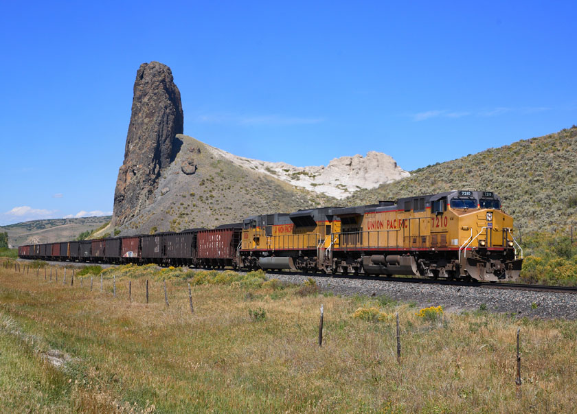
Any layout based on the Craig Branch would be focused on its primary traffic...Coal. Lots of Coal. Crews of the coal trains pick up their trains in Phippsburg, take them to the mines and return the train to Phippsburg. Both East and West of Phippsburg are two summits, Toponas to the East and Pallas to the West. Since crews change at Phippsburg, it seems that most models of the branch would be centered around Phippsburg. Fortunately, just east of Phippsburg is a signature scene on the line, Finger Rock.

Further East, the line passes through Yampa, Colorado before cresting Toponas Summit and then descending through Energia Canyon and Rock Creek Canyon enroute to Bond. Both canyons are spectacular scenic features, but essentially inaccessible. However, the line does possess several steel trestles (a rarity on the D&RGW), and multiple tunnels.

West of Phippsburg, the line climbs to Pallas Summit, before descending past the Edna Mine complex, inspiration for the Walthers New River Mine Kit, through picturesque Steamboat Springs, and on the the end of track at Craig. Several branches depart to various coal mines en route. The land becomes increasingly range land, and several switching opportunities exist around Craig. The primary non-coal traffic on the line is a once a week local to Craig, crewed out of Phippsburg.

A very interesting plan for a Craig Branch focused layout was designed by Bernie Kempenski and published in Model Railroader's Mid Sized Track Plans for Realistic Layouts. I am a big fan of his modeling and layout plans. His track plan captures Rock Creek Canyon, Phippsburg, Craig and one of the coal branches along the line. For its size, it is a nice plan which would be fun to operate. However, I worry that the limited traffic of this line might ultimately lead to boredom. A more complete model of the line would add interest with additional mine runs, and more extensive helper operations. A little modelers license could add some additional industry along the line, particularly for agricultural and oil and gas operations. The addition of a "Ski Train" to Steamboat Springs could add further interest. But really, to get a wide variety of operations, extending the model to include Bond and the Moffat main line is important in my eyes. At least then, a parade of trains through Bond could be modeled, while operations would focus on the branch activities. I've actually operated on a very nice layout that modeled a short stretch of mainline, with plenty of through traffic, but which had operations focused on local trains that ran off the main to several branches. So it can be done. What would my representation of the Craig Branch look like? Let me try to lay out the concept.

I'm very fond of the concept of Layout Design Elements (LDEs) coined by Tony Koester. Another railroad author of whom I am a big fan. However, I separate them into two types - operational and scenic. Operational elements exist to support model operations, while scenic elements exist for the purpose of providing visual separation between operational features. Such elements are essential for the operators to give a sense of distance and to provide time between operational stops. In this concept, I think the following Operational LDEs should be represented:

  • Phippsburg - crew change point;
  • Craig - Main switching location;
  • Bond - Main line Junction and Main Line Crew changes;
  • Volcano Siding - the only siding on the branch where two coal trains can pass;
  • Edna Mine - now long gone, but it is such a signature element I would want to include it;
  • Steamboat Springs - Possible second switching destination, passenger destination;
  • Yampa - Possible third switching location; and
  • Branches - Ute, Energy, Empire and Axial branches all come off the Craig Branch, and one or more should be included.

What about the Scenic LDEs? I would try to include:

  • Finger Rock - Near Yampa/Phippsburg, a signature scene;
  • Toponas Summit - the major summit on the line;
  • Pallas Summit - the second summit around Phippsburg;
  • Energia and Rock Creek Canyons - these areas bracket the isolated Volcano siding;
  • The Climb out of Bond - two tunnels and a horseshoe known as Copper Spur; and
  • McCoy/Crater Loops - a scoria rock operation between Rock Creek Canyon and the climb out of Bond.

Is it do-able? Maybe. The concept does have the advantage of requiring a much smaller operational crew. Is it worth doing? Perhaps...