Showing posts with label Flatirons Tunnel District. Show all posts

Wednesday, November 20, 2019

Wordless Wednesday

A BNSF Passenger Special heads eastbound, passing between Tunnels 2 and 3. Photo by John Shine.

10 Days, 10 Posts to Go.

Cameron Turner

Tuesday, November 12, 2019

Tunnel 8

Tunnel 8 is the end of the Flatirons Region of the Tunnel District and the start of the Middle Region of the Tunnel District. As such, Tunnel 8 is a critical point of demarcation between the two regions in the Tunnel District.

The prototype Tunnel 8 penetrates beneath the peak of Eldorado Mountain to swing from a generally northerly direction to head west up South Boulder Canyon.

Satellite View of the Tunnel 8 Area.
The track swings to the right as it goes into Tunnel 8, and continues to the right as it plunges through the tunnel. This gives ample opportunity to use the hidden track to reorient the track to follow the benchwork.

The view of the east portal of Tunnel 8 at the west end of the Flatirons Region of the Tunnel District. Photo from Rio Grande Secret Places, Volume 1 by R.C. Farewell.

Further, since Tunnel 8 marks a change in scenery, it makes sense to physically separate the Flatirons Region scenes from those in the Middle Region. Tunnel 8 is the longest tunnel yet at 753 feet. This led to the track plan below.

Track Plan for Tunnel 8.

In the plan, Tunnel 8 begins with a curve to the right just as in the prototype. However, this turn pushes the track through the backdrop dividing the two sides of the benchwork. In turn, this leads to a reverse curve that extends the length of the tunnel so as to bring the tunnel back to the viewable side of the benchwork. This trick should work as the trackwork in Tunnel 8 will be below the scenery level on the opposite side of the benchwork. With some care, I should be able to make sure that the track is accessible. The overall tunnel length is a little long, at 69.1", but the portal to portal distance is about 59" which is closer to the prototype tunnel length of 44". However, given the location of the support post, and the desire to separate the scenes, the tunnel length works to minimize the impact of the support post on the west portal of Tunnel 8 scene.

The west portal of Tunnel 8 in the Middle Region of the Tunnel District. Photo from Rio Grande Secret Places, Volume 1 by R.C. Farewell.
The exit from the west portal of Tunnel 8 has very little curvature to it. The plan requires a little more curvature than the prototype, but not so much as to be unacceptable. While Tunnel 8 is a long tunnel at almost 6 feet in length, many of the trains I expect to run on the layout will be in the range of 7 to 15 feet, and thus trains should be visible despite the length of the tunnel. By the time the main line reaches Tunnel 8, the track elevation has reached 31 inches above the reference elevation. The deck separation at this point is ranges from about 16 inches at the low spots in the scenery, to approximately 24 inches at track level of greater. Furthermore, the flatirons occupy their own distinct area on the layout with a clear scenic demarcation to the middle region. I believe that this plan continues to work well.


18 Days to go. 18 Posts to go!

Cameron Turner

Monday, November 11, 2019

Tunnels 6 and 7

The Flatiron Region of the Tunnel District continues through Tunnels 6 and 7. Tunnel 6 is dwarfed by the massive slab of rock through which it is bored. Tunnel 6 is slightly shorter than Tunnel 5 at 32.8" but by placing it in the corner of the benchwork, it allows me to hide the turn to the right.

Track Plan for Tunnels 6 and 7.
East Portal of Tunnel 6. Photo from Rio Grande Secret Places, Volume 1 by R.C. Farewell.

As in the prototype, the entrance to Tunnel 6 is a curve to the right, so the plan captures the essence of the tunnel as well. Tunnel 7 on the other hand is a straight shot as can be seen below.

Tunnel 7 lies on a tangent stretch of track. Photo from Rio Grande Secret Places, Volume 1 by R.C. Farewell.
This too is captured in the track plan. A similar photograph should be achievable in the layout. Tunnel 7 is short, only 14.8" long, but again, all the tunnel lengths and the distances between the tunnels are proportional to the prototype.

The east portal of Tunnel 8 represents the end of the Flatirons Region of the Tunnel District. The west portal lies in the South Boulder Creek drainage as part of the Middle Region of the Tunnel District. That will be our next stop.

19 Days to go. 19 Posts to go!

Cameron Turner


Saturday, November 9, 2019

Tunnels 2, 3, 4, and 5

Finally, we get back to new trackage. I'm pretty happy with the potential of the new benchwork configuration, so the plans from here on out, use that configuration as their basis.

Just to the west of Plain siding, we hit the Flatirons portion of the Tunnel District. The Tunnel District itself contains 28 tunnels in 17.1 miles. Tunnels 2 to 29 includes 26 tunnels in about 10 miles, which is one of the highest concentrations of tunnels in America.

Two tunnels are now defunct, Tunnels 9 and 28, and the two tunnels at either end of the tunnel district, Tunnel 1 and Tunnel 30 are both isolated from the rest of the district. The rest of the Tunnel District can be divided into three regions. The first region is Tunnels 2-8, which comprise what I call the Flatirons Region of the Tunnel District. Tunnel 8 is the dividing line between the Flatirons Region and what I call the Middle Region, which extends to Tunnel 18 and Crescent Siding. The Middle Region lies along South Boulder Creek, although for the entire run through this region, the creek lies a considerable distance away from and below the railroad. Beyond Crescent Siding, the Upper Region of the Tunnel District, Tunnels 19-27 and Tunnel 29, lie much closer to South Boulder Creek and even run along the creek itself.

Tunnels 2, 3 and 4 in the Flatiron Region of the Tunnel District. Photo from Chuck Conway's Heart of the Rockies.
This scene has been similarly captured by Mike Danneman in his layout.

Tunnels 2, 3 and 4 on Mike Danneman's Layout.
Physically, there is a short separation of single track between Plain siding and Tunnel 2. I wanted to capture that in the plan. Immediately after Tunnel 2, the line sweeps across Bull Gulch on a massive fill. Bull Gulch washed out in October 2013.

DRGW 5390 climbs WB out of Tunnel 2 and across the fill at Bull Gulch. Photo from Chuck Conway's Heart of the Rockies.
Bull Gulch Washout, October 2013 from Below.
Bull Gulch Washout, October 2013 from Above.
After crossing the fill across Bull Gulch, there is a cut through a protruding flatiron slab and then the line enters into Tunnel 3.

East portal of Tunnel 3 with DRGW 3123 and 3156 headed westbound in 1991. Photo from Rio Grande Secret Places, Volume 1 by R.C. Farewell.
Tunnel 3 is often described as a slot through the Flatirons.Tunnel 4 is quite similar, but the west portal emerges from a substantial flatiron formation that leaves much of that portal in shadow. Photos are difficult to come by but some do exist.

West portal of Tunnel 4 with SP9731 leading a passenger special west. Photo from Rio Grande Secret Places, Volume 1 by R.C. Farewell.

East Portal of Tunnel 5 presents another penetration of the iconic Flatirons southwest of Boulder, Colorado. Photo from Rio Grande Secret Places, Volume 1 by R.C. Farewell.
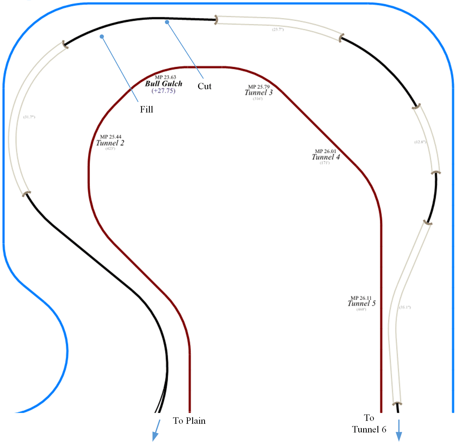
So, with all of these iconic images through the Flatirons in mind, I have put together the following track plan that brings the mainline off the second peninsula and along the wall above Leyden Siding.

Track Plan for Tunnels 2-5 through the Flatirons.

So, in this plan, I have a short section of single track between the west end of Plain, and the east portal of Tunnel 2. Tunnel 2 with a length of 31.7", bends around the corner, and the curve continues across the fill of Bull Gulch (over a 33" radius). The mainline cuts through a slab of the flatiron formation, and then the main plunges into Tunnel 3 for another 23.7". These both seem to be long tunnels, but both are proportional to the actual tunnel lengths, as it the spacing between them. Those proportions are continued throughout the Tunnel District. After another brief appearance, the line enters Tunnel 4 for 12.8", appears again along a 21" radius curve (instead of a tangent as in the prototype) before plunging into Tunnel 5 for the next 35.1". Most trains will be continuously playing peek-a-boo during the transit through this part of the layout.

In the plan, I show the tunnel portals, and the width of the tunnel itself. I've hidden the track centerline itself in the plan above. The train continues its climb from Plain (at 26.5") to the west portal of Tunnel 5 (at 29.3"). The entire scene is 17' long, and the resulting grade is about 1.3% which should be enough to be noticeable, but should not be a severe operational impediment. The ruling grade remains out in the open through the Big 10 curves. I think that the scene will be both impressive and immersive in its effect. I am excited about seeing it in reality.


21 Days to Go. 21 Posts Remaining.

Cameron Turner