Showing posts with label Narrow Gauge. Show all posts

Thursday, August 29, 2019

An Ops Moment

Last Sunday, I had another Ops Moment. I got a chance to operate on the NEW Arcadian Coast Eastern (ACE), built by my friend Sandy Eustice. Sandy's ACE is a prototype model of the 6th Maine 2-Foot Gauge Railroad. And if you are thinking that "Wait a minute, there were only five Maine 2-footers." Well, you should talk to Sandy because he has a sixth in On30.

Sandy's Map of the Arcadian Coast Eastern.
The ACE connects with the Maine Central in Hancock, runs along the coast past Sorento to a wye at Frenchman Bay. From there, the main continues along the coast to Winter Harbor at the end of the main line. However, a branch runs off the main at the wye at Frenchman Bay to the town of Tunk Lake. In essence, the layout is three major switching areas, coming off a single wye. It is a novel design, and it allowed Sandy to have a nice operating On30 layout in a spare bedroom.

Trains originate from Winter Harbor, and either run via Frenchman Bay and Sorento to Hancock, or via Frenchman Bay to Tunk Lake.

ACE #6 with the Winter Harbor engine facilities in the background.
Apparently, someone important is either departing from Winter Harbor, or arriving as there is a fancy car waiting at the station.
Sandy and I each took trains. On the first shift I ran a turn out to Hancock and back, while Sandy worked up to Tunk Lake. Trains are fairly short 5-7 cars, but they are just right for the towns. Hancock resides on a 16" wide shelf, which is not a lot in On30, but there is enough track to get the jobs done, if you think your way through it. Hancock is also the location of a highly efficient interchange with the Maine Central, that rapidly transloads cars between trains.

A GGYV&N box car takes on cargo from the Hancock Freight House and an REA Truck.

The Hancock station is a popular place.
After my run to Hancock and back, I straightened out the yard and spotted cars from Hancock in Winter Harbor. That allowed me to build the afternoon fish train to Hancock and the afternoon turn to Tunk Lake. Tunk Lake resides on the third peninsula of the layout room. Since there is no run around track in Tunk Lake and the grades into town are steep, the engine needs to push cars from Frenchman Bay to Tunk Lake. I first ran the Fish train to Hancock while Sandy handled a few RIP cars and was able to return in time to take the afternoon train to Tunk Lake.

The Hancock County Growers Association, an industry in Tunk Lake.

Tunk Lake is home to a large sawmill complex.
While I ran to Tunk Lake, there was one final run to Hancock and back to catch the evening connection with the Maine Central Calais Branch which Sandy took out. Returning to Winter Harbor, we put away the evening cars, and tied down the engines. Another day on the ACE had come to an end.

Car movements are governed by a 4-cycle car card system. There are a few modifications to the cycle to allow cars to be unloaded and reloaded in Hancock so that the town remains fluid, but the system works well.

Tunk Lake and its car card box.

A layout does not need to be large to be fun to operate, just well thought out, and the ACE qualifies as a well thought out layout that is a pleasure to operate.

Cameron Turner

Tuesday, September 11, 2018

A Sidebar Project

I have some side interests. And sometimes they take my attention away. I had been planning to finish the bridges for the T Layout, but somewhere I misplaced a set of 3D printed detail parts. So, just order replacements right? Well, I decided that I didn't want to do that until I had a few other files ready for printing, and these files involved cars for an HOn2Z Gilpin Gold Tram layout I have been toying with as a short term project. The key to the layout, and whether or not I pursue it though is the ability to make the cars/engines the way I want to, namely, not in HOn30, but in what I have taken to calling HOn2Z.

Yep, rather than use N-gauge track which is really about 30" in HO, I decided that I really liked using Z-gauge track. A quick calculation showed that the 6.5 mm gauge is a little less than true HOn2 (which would be 7 mm gauge). I was even a little surprised to find out that there is an HOn2 set of NMRA standrads for 7 mm gauge, so this is not going to be HOn2. In fact, technically, it is 22.3" gauge, so really, it might be HOn22, or as I coined it HOn2Z.

By using Z, I can use existing track if I want, particularly turnouts like the new Atlas Z scale turnouts. Plus, I already have done a lot in Nn3 which also uses a 6.5 mm gauge, so it makes sense. Add in wheels and trucks from Microtrains, and a bunch of mechanisms - well, I like HOn2Z. So, now for the cars.

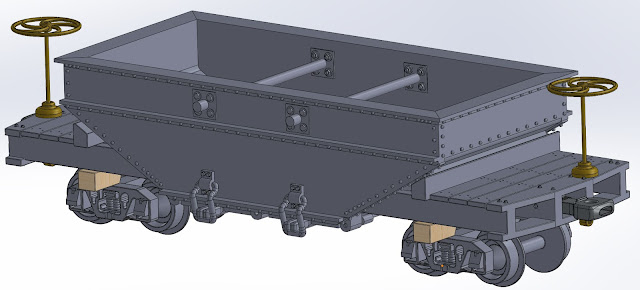
Well, I got a bunch drawn up for printing to pass the Shapeways requirements. The Gilpin has 3 ore car types as shown below.

Gilpin Half Cord Ore Car (Type 1)

Gilpin One Cord Ore Car (Type 2)

Gilpin One Cord Ore Car (Type 3)
I designed them around Andrews Style Z-scale trucks from Microtrains. The wheels are close, but a little small for most of the Gilpin cars, although the truck style is wrong. I decided to live with the wheels so that the cars operate well, and have a consistent coupling height (Gilpin cars actually had different coupler heights over the years). With a little work, MT couplers could also be installed, but I went with a Link-Pin Style coupler that I designed and had previously tested. I figure if you are going this far, might as well do that well too. Seeing these three car types together really shows the differences.

Left to Right: Gilpin Half Cord Ore Car (Type 1), Gilpin One Cord Ore Car (Type 2), Gilpin One Cord Ore Car (Type 3)
I've also drawn up a set of flat cars. I have drawings for the flat car, and the flat car with stake pockets, but the flat car with stakes is presumed. After all, if you had stake pockets, why not stakes too.


Of course, the stake pockets were likely used to make the gondolas, just as I did in the model.


And, they were also used on the excursion cars.


And, while the Gilpin didn't have any, it is fairly easy to imagine a box car as a combination of a flat car with stakes, and a similar (albeit slightly longer) box car found on some of the Maine 2-foot roads.


In addition, another set of modifications led to the longest car on the Gilpin, at 23 feet, the water car. A few elements of this are plausibly imagined, as the data and pictures simply don't provide answers, but I think it will look reasonable.


Test prints of each are on their way, and I have a few more cars to finish, before tackling the engines. But with some cars coming, track was next. I did find some data about the ties used, and from that, designed a track jig. And using a home grade 3D printer, proceeded to make some tie jigs. 


Each section has a pinned connection to align them. And once they are assembled, I am planning to mount them on a painted poplar board from the local lumber yard. 


I am currently painting the tie gigs to help locate the PC clad tie locations, but once that is done, I will have a tool to lay ties for a couple of feet of track to display my cars, and to include a prototype handlaid stub turnout (just like the real ones used on the Gilpin). So, I may not need the Atlas turnouts, or I may simply use stub turnouts in certain places, and model the line as slightly more modern and upgraded than the actual. If I do build a little layout, it will almost certainly be a protofreelance line, rather than a Gilpin model. After all, I am already going there with the box car. But more on that in a later post.

Monday, March 27, 2017

A Little bit of a Narrow (Gauge) Imagination


A little imagination goes a long way. And with narrow gauge modeling, it goes even further. I started model railroading with my father and an O scale layout. By high school, I moved to HO, and by college, I moved to N. By the time I was in graduate school, Nn3 seemed to be the way to go, because of both the small size and the challenge. I even built nearly a scale mile of Nn3 modules that I took to the National Train Show in St. Louis in 2001. I still enjoy tinkering with narrow gauge ideas, and layout plans. But, as I have become increasingly interested in operations, it isn't the small size of Nn3 that makes me hesitate, but my feeling that the operations are kind of small, low density affairs. I've operated enough in both N and Nn3 to feel like I can operate in those scales. I've also operated both on standard gauge and narrow gauge layouts. Both can be satisfying. But I find that the narrow gauge lines, to remain plausible, just do not have the feel of operating a standard gauge line.

One particular inspiration in how to get the operations "feel" I want, but model narrow gauge is to copy Bob Hayden's approach on the Carrabasset and Dead River Railway. The C&DR is a Maine 2-footer, but models an era after which all the prototype lines had been abandoned. And it is not a fading concern, but a healthy, vital railroad, featuring new diesels, passenger service, and even innovations such as unit trains.

Image result for carrabassett and dead river model railroad Hayden

In some ways, the prototype equivalent is the White Pass and Yukon Railroad in Alaska, that operated as a narrow gauge freight line until 1982, and now operates as a tourist line. The line operates primarily with diesels, and even sported intermodel trains at one point.


It is as a healthy going concern that I imagine my Rio Gorre Northern. As one of my other hobbies is the history of the atomic bomb, I even think I would set the layout in 1952, shortly before the H-bomb was first tested. Part of the theme of the layout would be that the line serves and provides transportation of military-grade equipment and materials needed for the nuclear arsenal. Were this equipment goes exactly is a little bit more of a mystery, but there are rumors of a secret town hidden in the northern mountains of the west. And there are rumors of a mysterious black train that runs at night delivering personnel to this location, the so called "Black Goose." Most locals laugh at the legend of this train which does not exist, but train crews are always wary to clear the line when the goose is making its mysterious run...although none can say that they have ever seen it.

In my imagination, the line begins at a port town. The port itself is known as Port, and the town as Porthmadog. Out of this terminus, runs a branch to the town of Gladhaven, a fishing and lumber town. The main climbs to summit its first range at Furlow Pass, and descends into the major terminal of Gorre. Gorre is the major terminal on the line, and from Gorre run a number of branch lines to various destinations. The line leaves Gorre, and climbs a second summit with the twin stations of Alpine and Tundra, before descending once again to a standard gauge line at Kaybeck.

The standard gauge connection could be any of a number of railroads, and might change to fit my fancy. And the branches may be operations of other lines, such as the Alpine, Kaybeck and Tundra (AKT), the Alpine Central (AC), the Gorre and Northern (GN), the Big Water and Tall Timber (BWTT), the Devils Gulch and Helegon (DG&H), The Gorre, Daphetid and Northernly (GDN), etc.

Along the way, we would see sights that resemble, the Georgetown Loop, Forks Creek, Ophir, Lizard Head Pass, Trout Lake, the Highline on the RGS, the Highline on the Durango and Silverton, Vance Junction, Windy Point, Cumbres Pass, spectacular bridges, and mines, mills, logging, and livestock. Power would be a mix of steam and diesel, and the cars would e an eclectic collection of long gone roads. Roads are not penetrating this tough country, at least not easily, and thus the railroad is the lifeline. Some say that the military has something to do with that, preferring the lack of roads and the resulting isolation to becoming a well trafficked area. Basically, the railroad would be my favorite everythings.

I don't really have LDEs for this line. It is the most freeform and undefined concept I have. I've always kept it that way so that I can imagine it in whatever space I have. I have looked at it as both a home layout empire, but also as a portable railroad that I could take to train shows. But it would not be a display layout, as much as an operating demonstration layout. However, I have also thought of it as a starter layout. Something small, that can begin operating in say 12 months, and brought to completion in 2-3 years - that would give me something to enjoy, while the larger layout was pursued, and would give me something that could live beyond the larger railroad empire.

Tuesday, March 7, 2017

Into the San Juans

Growing up, I often got to go camping with my father at a small campground above the town of Silverton, Colorado. We would be there about a week, and we had ample opportunities to explore the areas around Silverton. We would drive up to Animas Forks, hike around Red Mountain, stop in Ouray, visit Ridgeway and Durango, and watch the new Durango and Silverton Railroad arrive in Silverton before racing to beat the crowd to the Pickle Barrel for lunch, before going to Smedley's Ice Cream Parlor for root beer floats.


Silverton is an interesting railroad town. Isolated in Baker Park, no less than four narrow gauge lines radiated out from town. The Silverton Railroad climbed over Red Mountain Pass serving the mines north of Silverton towards Ouray, before topography prevented the line from descending into Ouray. The Silverton Northern extended out of Silverton along the upper Animas River,  first to Eureka, and ultimately to Animas Forks to serve mines including the Sunnyside Mine. A third road, the Silverton, Gladstone and Northerly, wandered up the course of Cement Creek, to th town of Gladstone, serving the mines there. While different entities, all three lines were ultimately owned by Otto Mears, and operated as a unit.

But Silverton had a fourth line, the Denver and Rio Grande Western, reaching the line via a branch from Durango. Thus, Silverton became something of an oddity, a rare location where multiple narrow gauge lines interchanged. Even at the other end of the branch, a similar situation evolved. In Durango, not only did the D&RGW come in from the east from Chama, but the Farmington Branch went south, and the Rio Grande Southern extended north, working up through Telluride to connect to the D&RGW at Ridgeway, where the D&RGW came through on the Marshall Pass line. In addition, at this end of the line, was the D&RGW Ouray Branch, that came within a few miles of the Silverton Railroad. In fact, the Silverton Railroad came within about 5 miles of Pandora, at the end of the RGS Telluride Branch. Admittedly, there was a pretty big mountain between the two, and so by rail it was closer to 150 miles, but, the point is, these lines were all intertwined into the same area.

The RGS is famous in its own right, climbing over Dallas Divide, Lizard Head Pass and Cima Hill and the lesser known Millwood Summit between Ridgeway and Durango.Towns such as Rico, Mancos, Dollores, Ophir, and Vance Junction all dotted the line. And there were bridges of all sizes all along the line. The RGS is at least as common a modeling subject as the D&RGW, and the two were very much intertwined.

Many of the towns, and mines and mills in the area are fascinating subjects. And in N-scale, several would make fantastic models that could be done with limited or even no compression. Many of these roads saw smaller steam engines, instead of K-36s and K-37s, K-27s and K-28s were common, and a number of consolidations (C-class) 2-8-0's also served the area.
K-27 DRGW #463

DRGW K-28

RGS #40 (Consolidation)

So, if I was to build a San Juans layout, what might it look like. Well, first there is a clear choice to make, 1) anchor the layout in Durango, or 2) anchor the layout in Silverton. Durango was the larger set of facilities as the terminus of the D&RGW, with both the Silverton and Farmington branches radiating out. The RGS becomes a essentially a bridge route between the four corners region of Colorado, New Mexico, Utah and Arizona, and the D&RGW mainline north of Ridgeway.

Silverton on the other hand is a hub, but it is the hub at the end of a branch line, and really, the three Silverton roads are just branch lines off the branch line. Traffic would be in any realistic scenario, much less on a Silverton centric model, than on a Durango centric model. Furthermore, by World War II, the Silverton lines were essentially over, whereas the RGS continued into the Post WWII era.

Part of this success was the presence of Uranium ore on the line, and its need for the Manhattan Project. As I have worked at Los Alamos National Laboratory, and have a bit of a hobby in learning about Atomic History, this is intriguing. Furthermore, it is plausible to formulate a history where the RGS did not just struggle into the post WWII era, but maybe even prospered due to its atomic connections. While I am not opposed to modeling an era set a century or more ago, I am more drawn to a post-WWII era, and one of my favorite model railroads, Dave Frary's Carrabasset and Dear River, did just this to extend the life of a Maine 2-footer into the post WWII era. So, if a Durango Centric line is my preference, what would it look like?


Well, I think you start with Durango. The line to Chama, and the branches to Silverton and Farmington continued to operate into the 1960s and beyond, in part due to the oil and gas discoveries near Farmington. Much of this traffic came via Chama, but by then, the RGS was long gone. Perhaps if it was still there, the traffic could have come via the RGS. In this scenario, the RGS could have become central to the production of Uranium, and so the line may have even prospered after WWII, long enough to benefit from oil and gas discoveries in the 1960s, and even maybe to become a bridge route of sorts between the central railroad corridor and the southern railroad corridor. Maybe not likely, but not entirely implausible, particularly with a military-industrial complex need to maintain the line and perhaps discourage easy alternative access (so as to protect the resources in the event of an attack). Maybe it even becomes a transition era steam/diesel NG railroad more like the White Pass and Yukon.

So, what might the operational LDEs look like? I think that they would include:
  • Durango (Connections to Farmington, Chama, and Silverton)
  • Mancos/Dolores
  • Cima Hill
  • Millwood Summit
  • Rico (Enterprise Branch)
  • Lizard Head Pass
  • Ophir
  • Vance Junction (Telluride/Pandora Branch)
  • Vanadium (Uranium Source)
  • Dallas Divide
  • Ridgeway (Junction with D&RGW - NG to Grand Junction/Gunnison & Ouray Branch - or - SG to Grand Junction)

Scenically, the LDEs might include:
  • many of the bridges enroute
  • the Highline by Ophir
  • Trout Lake
  • Dolores Canyon
  • and so many more...

There is honestly a lot of potential scenery here; much more than I can think of on the top of my head. There is obviously a fascinating railroad here. I am more than a little tempted to imagine narrow gauge diesels in a black and orange scheme for the RGS... In Nn3, there are now some very nice steam engines, or at least chassis options, based on Z-scale Japanese steam and from offerings from AZL. But more exciting, the diesels have dramatically improved with GP-7s, GP-9s, new F-7s, GP35s, and SD40s all becoming available. At the very least, these new chassis become the basis for a lot of interesting models, or free-lanced models that could be deployed. Even DCC and sound are becoming practical in Z and Nn3. This could be a very interesting railroad indeed. And in fact, I am aware of at least one massive Nn3 project to build a model of the RGS. Having played with Nn3 myself, I am convinced that it could be operable as a layout. And, both this and Marshall Pass offer the ability to operate with a much smaller crew, and yet not be unrealistic, as these lines often had a much lower traffic density than the standard gauge routes discussed thus far. Since I am not sure how much of a crew I can draw, this is a consideration.


Thursday, February 23, 2017

The Fabled Marshall Pass

The Marshall Pass roue was the original narrow gauge rout between Denver and Salt Lake City. The 3rd Division as it was called ran from Salida to Gunnison over Marshall Pass. From Gunnison, the line continued west through the Black Canyon of the Gunnison over Cerro Summit, and ran into Montrose. The line closed in the early 1950s, and was torn up by 1955, with the exception of the Monarch Branch which was standard gauged and continued operating that way into the 1980s.  The Marshall Pass crossing crested the continental divide at 10,842 feet, well above Tennessee Pass and the Moffat Tunnel.


As the primary narrow gauge line of the D&RGW, the line saw impressive narrow gauge traffic into the 1940s, but after WWII that traffic began to drop dramatically. The largest D&RGW narrow gauge engines, the K-36s and K-37s plied the line.

K-36 DRGW#489

K-37 DRGW#494


The line was severe, with 4% grades, and multiple turnback curves. Much of the line over Marshall Pass is still there, and can be driven in the summer months. 


From Salida, the line headed west to Poncha Junction, where the line swung south and the Monarch Branch continued west towards Monarc Pass. Shortly thereafter, the line reached Mears Junction, a unique junction where the D&RGW crossed over itself, with one line continuing to Marshall Pass and another climbing over Poncha Pass to descend into the San Luis Valley and Alamosa.

The main continues up the pass, winding through Shirley and Gray's, ultimately cresting the pass and encountering a major snowshed to protect the crossing. The snowshed covered the station, a passing track and even a turntable. 


Marshall Pass Snowshed.


Western Side of Marshall Pass.

The western descent is also significant. The line descends through multiple curves through Shawano, at times allowing the train to pass through the same scene at least 4 times! This stretch o the line is remote, We work through Chester and Buxton and Sargent. From there, the line opens up, and runs across the valley to Gunnison. Gunnison was a division point, and the connection to additional branch lines. The main continued west out of Gunnison, and plunged into the Black Canyon of the Gunnison. This canyon was followed through the canyon until Crystal Creek enters the canyon. At this point, the canyon became so rugged that the line had to climb out of the confines of the canyon, and crest a ridge known as Cerro Summit, near the town of Cimarron. This pass was unspectacular, especially against such passes as Cumbres, Tennessee, Palmer, and Marshall.


Much of this route between Gunnison and Montrose now lies underwater. But along te route lies places such as Sapinero, and Curecanti, places that inspired the original D&RGW logos and advertizing. Now, Blue Mesa reservoir hides much of this region.

Image result for Curecanti Needle photos

The railroad grade is somewhere below the surface.

I have built numerous Nn3 modules using Z-scale track, mechanisms and trucks, to represent N-scale Narrow Gauge. Modeling this line would be a significant shift of focus from the D&RGW standard Gauge to its narrow gauge operations. 

Salida - if modeled as more than staging would still allow for the standard gauge to make an appearance. But the yard in Salida would be dual gauge, possible, but much more complex to model. However, operations including the Monarch Branch would be fascinating. The modeling of the route over the pass would be feasible, and Gunnison, as a Narrow Gauge division point supported several branch line operations. A little modelers license would allow for sufficient traffic on the line to be interesting. In particular, helper operations on both the East and West side of Marshall Pass.

A chief question becomes how far west to model. Gunnison makes a lot of sense as the end of the line, but modeling the Black Canyon is more than a little tempting. Recapturing something long gone has its appeal. However, one of the challenges, is that there is a lot less published material on this line than on lines that existed into the modern era. Not living in the region anymore, makes it a bit more difficult to reconstruct the line in sufficient detail to produce a solid model. These are all challenges, plus the fact that while we are seeing some solid steam engines in Z that could be rebuilt into Nn3 K-class locomotives, that would be a fair bit of work to build a prototype roster. It certainly is tempting to instead look at building this route, had it made it into a diesel era due to some source of new traffic discovered after WWII.


So, what would the operational LDEs be:
  • Salida;
  • Poncha Junction;
  • Monarch Branch;
  • Mears Junction (connection to San Luis Valley Line);
  • Shirley and Gray's both had sidings and Water tanks;
  • Marshall Pass;
  • Shawano;
  • Sargent;
  • Parlin (Pitkin Branch Connection); and
  • Gunnison (Crested Butte Branch, Balwin Branch, Kuebler Branch).

If extended to Montrose:
  1. Sapinero;
  2. Lake Junction (and the Lake City Branch);
  3. Cimarron;
  4. Cerro Summit;
  5. Cedar Creek; and 
  6. Montrose.
The Scenic LDEs would be:
  • Marshall Pass Snowsheds;
  • Hilden (Snowsheds and Siding);
  • Shawano Curves;
  • Some of the other siding locations (i.e. Otto, Keene*, Pocono*, Chester, Tank 7, Buxton, Elko, Crookton, Doyle, Bonita, and Steele) Note: * - Single Ended Sidings;
  • Black Canyon;
  • Curecanti Needle;
  • Crystal Creek Climb to Cerro Summit; and
  • the Crystal Creek Bridge.
I know a lot less about this line than I really should. But that too is part of the fun. Considering this route in some fashion is a chance to learn more about the line and perhaps decide that it should b the focus.